North Bute Circuit
Walking
Starting out from Port Bannatyne, this moderate trail for more experienced walkers takes in the more isolated upper half of the island, encompassing mainly moorland and forest
This tour is 15 miles long, please allow at least 4 hours 20 minutes to complete it, excluding the time taken to enjoy the destinations along the way.
The ground on this route can be boggy underfoot at times and map-reading skills are essential, given the secluded nature of the route. As you set out, look out for Kames Castle overlooking the Bay of the same name on your right. A little further on (also to your right) is the roofless structure which formerly operated as the Gaelic church of St Colmac. The early sections of the walk command stunning views across the golden sands of Ettrick Bay - make sure to look out for the signposts of the Ettrick Stone Circle on the approach to the Bay before the route climbs northwards towards the island’s secondary ferry port of Rhubodach. As the terrain crosses farm tracks and boggier moorland in the north, look out for the signposted Achavoulaig Butt – an abandoned 18th century settlement. The route loops back round to conclude at the bustling seaside settlement of Port Bannatyne.
What you'll see

Port Bannatyne - Isle of Bute
Towns & Villages
Port Bannatyne is a coastal village on the Isle of Bute.
04 The Bute

Kames Castle - Bute
History & Heritage
Kames Castle is located on the shore of Kames Bay near Port Bannatyne.
04 The Bute

Ettrick Bay Stone Circle - Isle of Bute
History & Heritage
The Ettrick Bay Stone Circle comprises eight stones, lying 130m south of St. Colmac Cottages.
04 The Bute
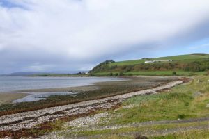
Ettrick Bay - Isle of Bute
Nature & Wildlife
Ettrick Bay is a stunning, wide sandy beach on Bute’s west coast.